Water Treatment plant
![]()
![]()
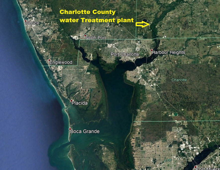
15- miles up river from the 41 bridge
Peace
River We all know the Peace river is here, but do you know how cool it is? Lets
start at the 41 bridges. Now the real mouth of the river is in a line from Ponce
DE Leon park in Punta Gorda across to Hog Island. So the Gilchrist bridges or 41
bridges as we call them are really a little over 4 miles up river.
To get to where the river is fresh all year is about 17 miles up where Horse
Creek enters the Peace river
or 22 from the mouth of the river. I thought I would throw that in as I get this
question a lot, most people do not under stand the Peace river is 104 miles long
and in the past a Major trade route for goods, before stage coaches and wagons,
I guess I should say before roads, heavy goods were transported by barges. Now
we use interstate Hwy but back then a lot easier to put a couple tons of stuff
on a boat and push it.
Now
lets get to the fishing, Snook fishing can be done on most of the peace river,
Zolfo Springs and Wauchula have for part of the Year some very good Snook
fishing. Even Tarpon can be found up the River.
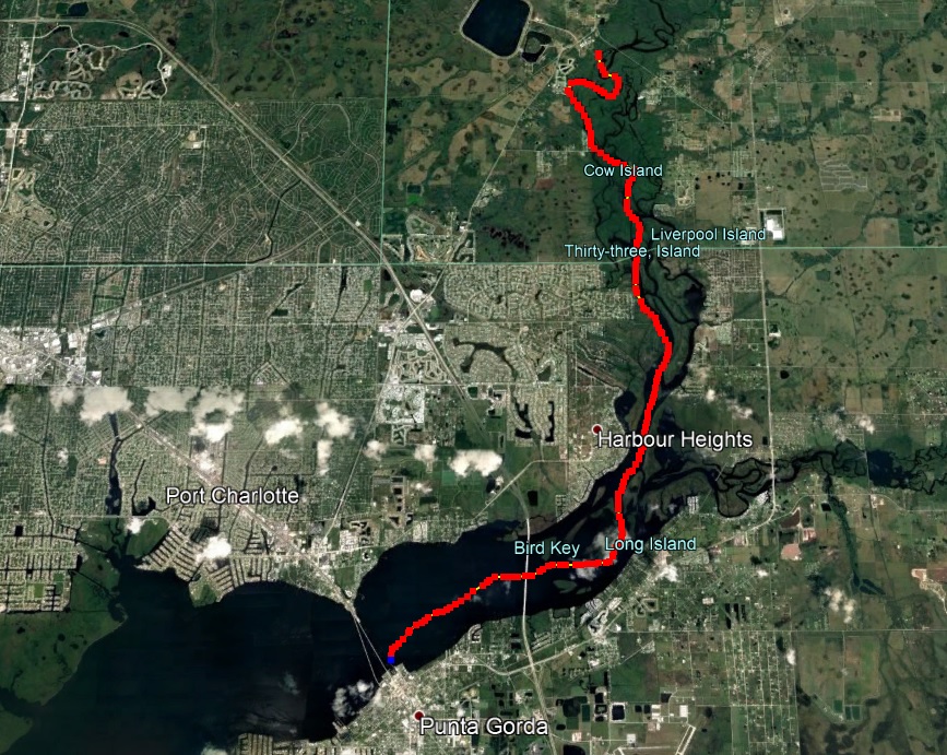
Back to a trip up the river, Starting at 41 you are in a full on Salt water
environment, as you pass the bridge for I-75 you are into a Mangrove
environment, still salt water now once you pass Harbor heights you will see saw
grass, This is where the transition starts, this is a true brackish water
environment. Now watch the shoreline as you head up river at Harbor heights take
the right fork and you will see the plants are changing more ferns, and the
trees are different the Mangroves thin out and the Cypress tress begin to be
more common, Watch Island 33 you will know which one this is as the channel
marks stop here, you have been seeing the typical Red or green markers now in
front of you is a marker with red and green on it, half and half. That is the
Charlotte county line. And the channels markers stop here this is also the first
place with less than 4 feet of water, you have been over holes deeper than 20
foot on your way here but in front of you is a shoal which extends all the way
across the main channel of the river and at high tides there is 3 feet of water
at lower tides less than 2. Now you can take and go around the back side of
island 33 and while there is not much more water the bottom is soft and you will
have no trouble making it through. In front on the main channel the bottom is
much harder and may ding your prop. I always use the main channel as I run a
flats boat and only need a foot of water to run comfortable. Once you are past
island 33 hold to the out side bends of the river and there is not really any
shallow places, until you get past the camp ground. And that is only shallow if
you are not thinking out side of the bends, which means you must picture in your
head an “S” follow the curves,
The fish will also hold on these out side bends. Near the shoreline and You
could cast a lure like a Rat-L-trap or a Bomber at the shore or I prefer to
troll these bends in the River. These bends get deep quick and it is a good idea
to idle over a bend to see where the deep starts, Pick a tree on the shore as
your guide. When I troll I am less than 5 feet from the bank so a certain tree
is a good reference point to know where the deep part of the hole is.
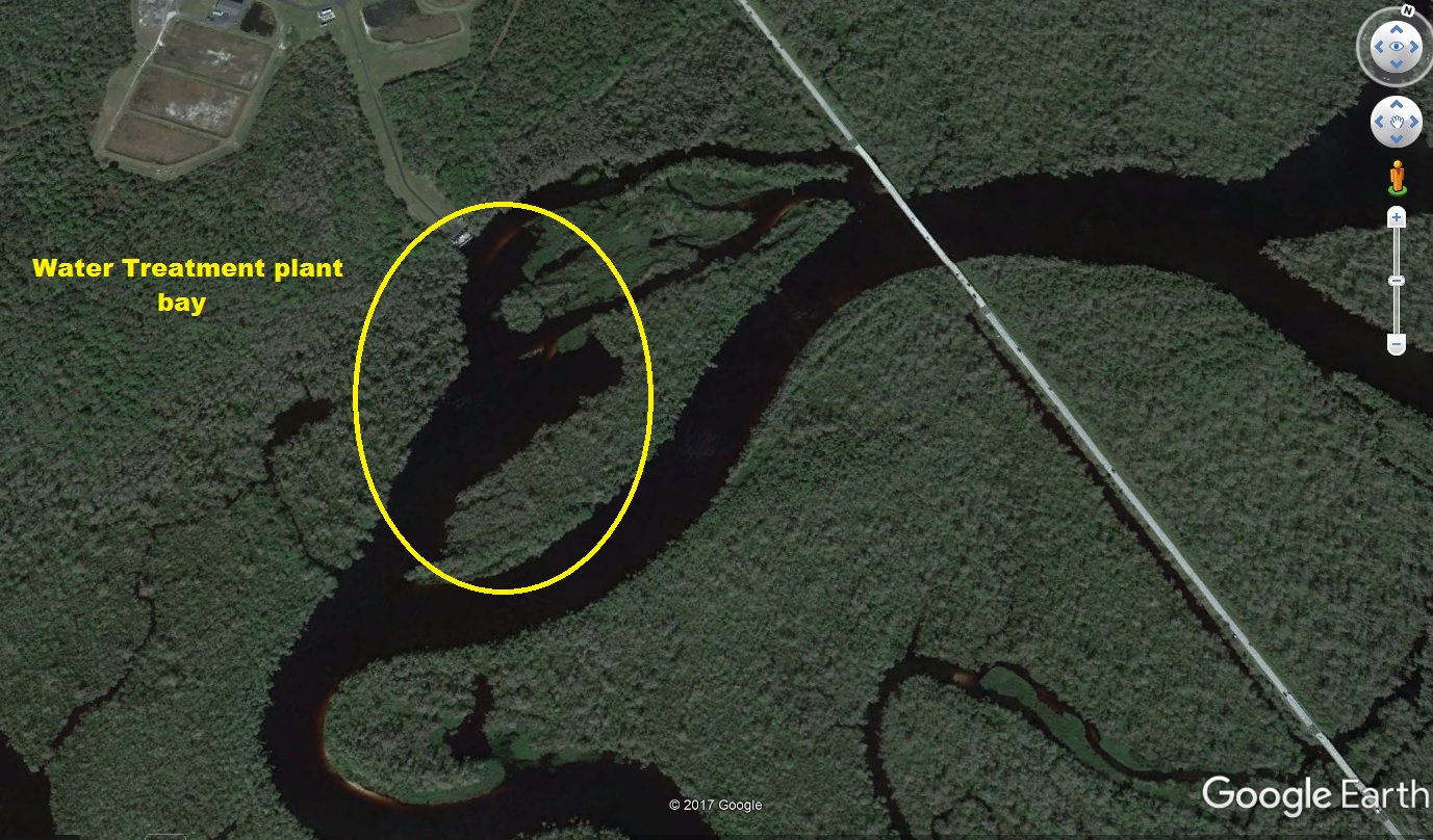
Now the only tricky turn is at the water treatment plant, you will be running
along and then find your self in a bay. The river had just taken a hard right
which you will not have seen and now you are in the bay where we in Charlotte
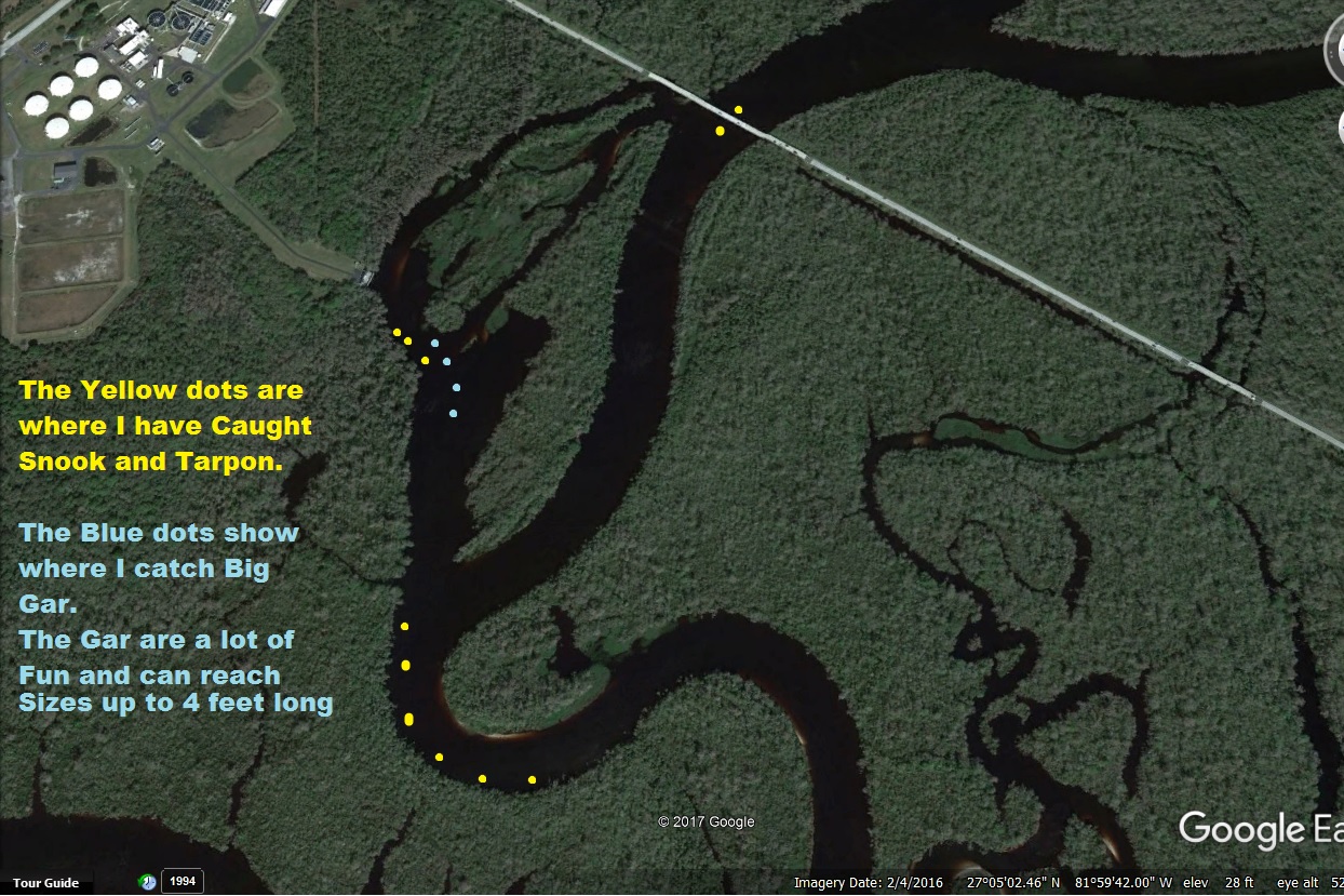
County get our drinking water from. I would take a few minutes to fish here.
In the water treatment bay there are often tarpon, and the Snook tend to lay up
along the shore line on your right hand side, I like to anchor out in the middle
and try for some of the giant Gar fish which live here not uncommon to find gar
over 4 feet long. A shiner under a bobber with a 4/0 wide gap/ Kahele hook is
the trick to fishing for them or catching them. If you are a Fly person, use a
2/0 hook with a piece of red ribbon, I would make the ribbon at least 4 inches
long, I like 6 inches then I shred the last 3 inches. This works the gar go to
attack the ribbon and their teeth get stuck in the shredded part.
Now
lets get back to the river Now the river tends to look like Jungle, think Tarzan
movies, Johnny Weissmuller filmed Tarzan movies here. It is the last transition
Until you get to the real world again up in Arcida. come out of the bay and make
a hard left and around the island you will see the bridge for hwy 761 go under
the bridge, and all the way to the left hand shore line. There is a sand bar
which comes off of the main channel of the river, which is on your right, If you
go straight ahead the Snook fishing is great on the left hand bank but it is a
dead end. Wait to head up the river until to get right in front of the main
channel coming from the right, that will take you to the Fort Ogden trestle,
where it is deep and the fishing is good right around the pilings. You may only
get a little ways farther up river from here, take this next ½ mile slow there
is no deeper section, and often fallen trees in the water at or near the
surface. You will make a left turn and there is a nice beach and some bug round
Piling maybe, I am sure at some time long ago there was a bridge or something
here this is the mouth of Horse Creek ahead of you there is what we call the
narrows, great fishing for Snook, Bass, Blue gills, even some times Red fish,
the main channel of the river goes off to your right but is really shallow less
than a foot deep. This is where I will stop as this is about where you need to
stop, I have not been up past this for a year so, I will make a run up there and
then I will continue our journey
to Arcadia and Points beyond as a last thought there is a great park in Arcadia
on Hwy 70 at the edge of town fishing is OK, for Snook and or Bass, but a really
nice park and a cool place to just check out by Car.